
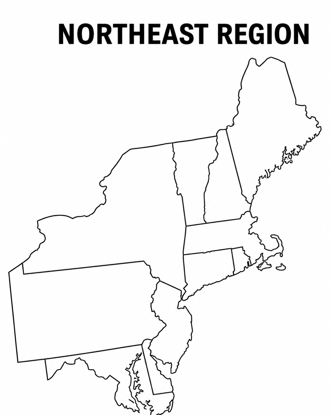
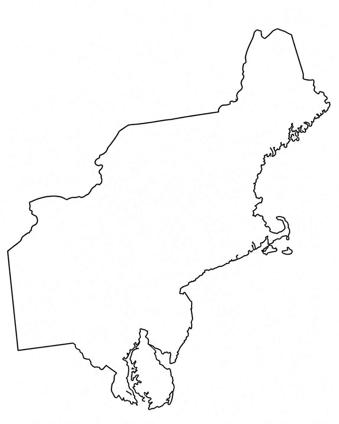
A Blank Map of the Northeast United States is one of the simplest ways to study the Northeast region. It provides students, teachers, travelers, and map users with a clear outline of the region, free from unnecessary labels, colors, or cluttered details.
You can use it to label states, mark capitals, color regions, practice borders, prepare worksheets, or plan routes. A blank US map works well because it gives the user space to interact with the geography, rather than just reading a finished map.
For classroom use, a blank northeast region map printable is especially useful. Students can write state names by hand, add capitals, trace borders, and compare the Northeast with other U.S. regions. For digital use, a PDF, PNG, or SVG version can be added to worksheets, slides, assignments, quizzes, and study guides.
Blank Map of the North East United States

Map of the North East United States

Blank Map of the North East United States with Colour

Blank Map of the North East United States Without State Boundaries

Printable Blank Map Of The Northeast USA

What is a blank map of the North East United States?
A blank map of the North East United States is an outline map of the Northeast region of the U.S. It usually shows state boundaries without labels. Some versions include only state borders. Some include cities, rivers, highways, or surrounding states.
A basic blank map is best for learning. It lets students fill in the details themselves. A more detailed map is better for reference, travel, planning, or presentations.
The most common version shows the Northeast region with state boundaries. A blank northeast region map PDF is often used for printing because PDF files keep the layout clean and easy to read on paper.
Read More:- Midwest Region Blank Map – Free
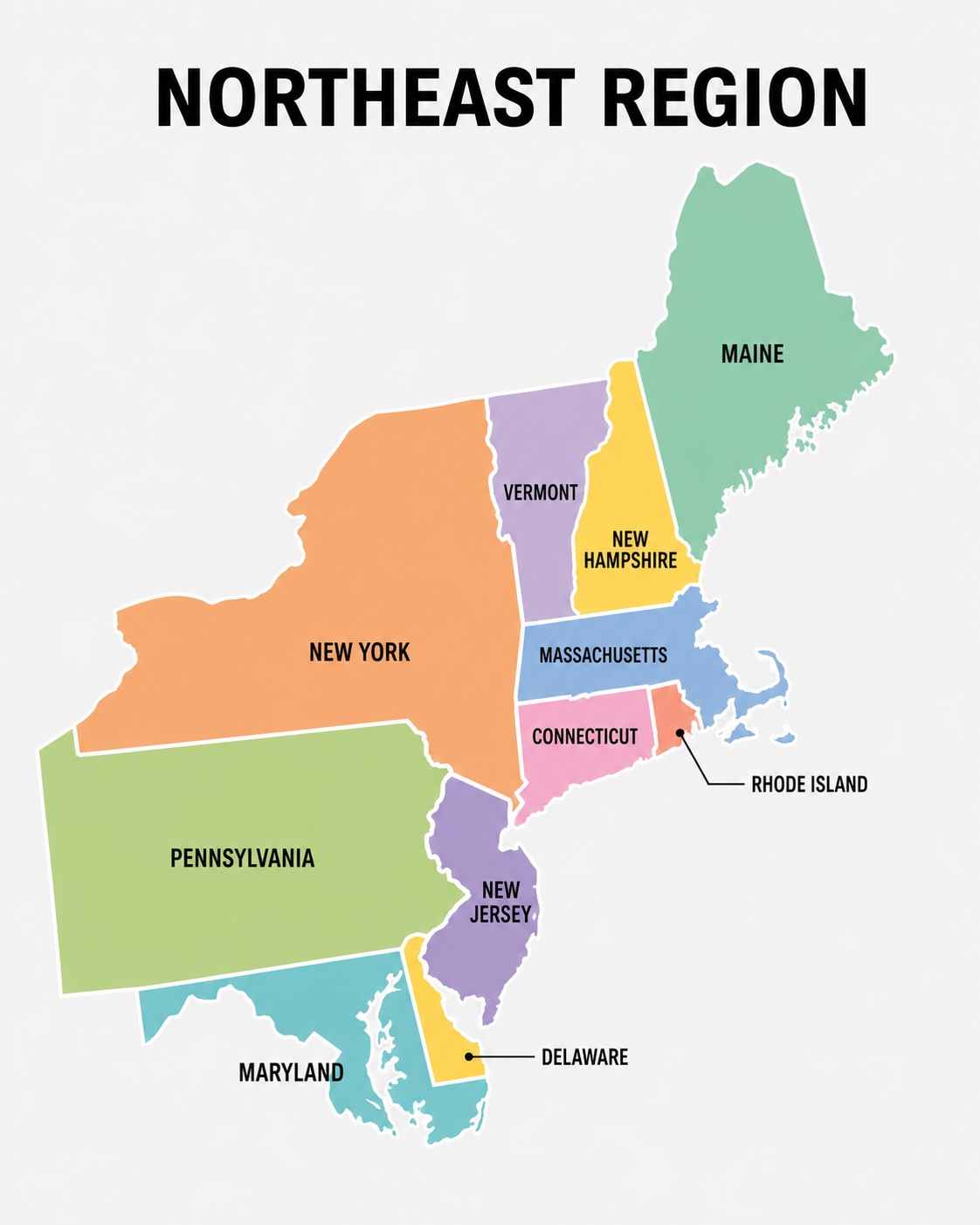
Which states are in the Northeast United States?
The Northeast region can be defined in more than one way.
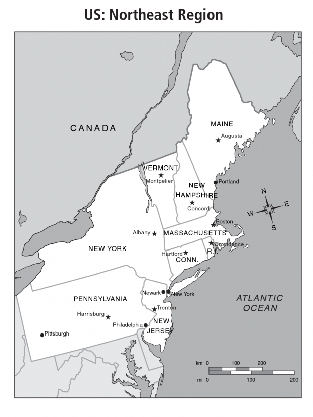
The U.S. Census Bureau defines the Northeast as 9 states:
- Connecticut
- Maine
- Massachusetts
- New Hampshire
- New Jersey
- New York
- Pennsylvania
- Rhode Island
- Vermont
These 9 states are grouped into 2 divisions: New England and Middle Atlantic.
New England includes Connecticut, Maine, Massachusetts, New Hampshire, Rhode Island, and Vermont.
The Middle Atlantic division includes New Jersey, New York, and Pennsylvania.
Many school worksheets and regional study guides use an 11-state version of the Northeast. That version often includes Delaware and Maryland along with the 9 states listed above. This is common in elementary social studies materials, especially when students learn U.S. regions through classroom maps, flashcards, and state-capital practice sheets.
For accuracy, choose the version that matches your lesson, worksheet, or purpose. A geography teacher may prefer the 9-state Census version. A 4th-grade social studies workbook may use the 11-state classroom version.
Why use a blank Northeast region map?
A blank map gives users an active way to learn geography. Instead of memorizing a list, they work with location, shape, distance, and borders.
Students can label the Northeast states, add capitals, shade coastal states, mark large cities, or compare the region with the Southeast, Midwest, Southwest, and West.
Teachers can use the same map in several ways:
- State labeling quiz
- Capital city practice
- Coloring activity
- Regional comparison worksheet
- Map skills assessment
- Cut-and-paste puzzle
- Homework sheet
- Answer-key activity
Parents and homeschoolers can use a northeast states and capitals map printable PDF for quick practice at home. It can also be used before a school test or as part of a U.S. regions unit.
Blank map vs political map
A blank map and a political map do different jobs.
A blank map usually has state borders without labels. It may have no colors, no capitals, and no city names. It is best for practice, quizzes, and worksheets.
A political map shows state names, borders, capitals, and sometimes major cities. It is better for reference. A student can study a political map first, then use a blank map to test memory.
For example, a teacher may give students a labeled study guide map on Monday, a blank map with a word bank on Tuesday, and a blank map without a word bank on Friday. This simple sequence builds recall without making the task too hard at the start.
Best formats: PDF, PNG, and SVG
Different map formats work better for different tasks.
PDF maps
A PDF is the best choice for printing. It keeps lines sharp and prevents layout changes when opened on another device. A blank northeast region map blank pdf is a good option for classrooms, printable worksheets, and handouts.
PDF maps are also easy to store in lesson folders. Teachers can print them again whenever needed.
PNG maps
PNG maps are useful for digital worksheets, presentations, and quick image use. A PNG can be inserted into Google Slides, PowerPoint, Canva, or a worksheet editor.
A PNG is easy to share, but it may lose quality if enlarged too much.
SVG maps
An SVG map is best for editing. Designers, teachers, and content creators can resize it without losing quality. SVG files are also useful when you want to change colors, remove details, or create a custom regional map.
For websites, infographics, and professional map design, SVG is often the cleanest format.
Common uses of a blank Northeast U.S. map
A Blank map of the northeast United States, free download, can be used in many ways. The best use depends on the amount of detail on the map.
1. States and capitals practice
Students can label each state and then write its capital. A northeast states and capitals map printable free worksheet works well for repeated practice.
Here are the 9 Census-defined Northeast states and their capitals:
| State | Capital |
|---|---|
| Connecticut | Hartford |
| Maine | Augusta |
| Massachusetts | Boston |
| New Hampshire | Concord |
| New Jersey | Trenton |
| New York | Albany |
| Pennsylvania | Harrisburg |
| Rhode Island | Providence |
| Vermont | Montpelier |
For an 11-state classroom version, add:
| State | Capital |
| Delaware | Dover |
| Maryland | Annapolis |
2. State border learning
The Northeast has several small states close together, especially in New England. A blank outline map makes it easier to see the shape and position of each state.
Students can learn which states border Canada, which states touch the Atlantic Ocean, and which states connect to the Mid-Atlantic region.
3. City and travel planning
A map of northeast usa with states and cities is better when the goal is travel, route planning, or regional research. It can show major cities such as New York City, Boston, Philadelphia, Pittsburgh, Buffalo, Providence, Hartford, and Newark.
A blank version can still be useful. You can mark the cities yourself, draw a travel route, or create a custom map for a trip.
4. Geography quizzes
Blank maps are ideal for tests because they remove clues. Teachers can ask students to label states, capitals, rivers, or neighboring regions.
For younger students, a word bank makes the quiz easier. For older students, a blank map without a word bank gives a stronger test of memory.
5. Coloring and regional activities
A blank map can become a coloring activity. Students can shade New England in one color and the Middle Atlantic states in another. They can mark coastal states, mountain areas, or states they have visited.
This works well for elementary geography because it combines visual memory with hands-on learning.
6. Content and design projects
Bloggers, designers, travel writers, and educational websites often need map visuals. A blank map can be used for custom illustrations, location pages, infographics, and comparison graphics.
For commercial design, check the license before using the map. Free maps may still require credit. Stock vector maps often need a paid license.
Blank map of the United States vs Northeast map
A blank map of the United States shows all 50 states. It is useful for national geography, U.S. regions, state identification, and full-country lessons.
A Northeast map focuses on one region. It gives more space to the states in that area, which makes the map easier to label. This is especially useful for the smaller New England states.
For classroom use, both maps are useful. Start with the full U.S. map to understand where the Northeast is located. Then use a regional map for detailed practice.
Detailed map of Northeast USA
A detailed map of northeast usa may include state names, capitals, major cities, highways, rivers, lakes, coastlines, and neighboring areas. This type of map is useful when blank borders are not enough.
Use a detailed map when you need:
- Major cities
- Road routes
- State capitals
- Rivers and lakes
- County or regional context
- Travel planning details
- Presentation graphics
A detailed map can also be paired with a blank map. Students study the detailed map first, then complete the blank map from memory.
Blank map of the North East United States with cities
A Blank map of the north east united states with cities gives users a middle option between a fully labeled political map and a plain outline map. It may show state boundaries and city dots without all labels filled in.
This type of map works well for:
- Marking major metro areas
- Planning road trips
- Studying state-city relationships
- Learning where capitals are located
- Creating travel or education graphics
For example, a teacher may ask students to label Boston, Albany, Providence, Hartford, Trenton, Harrisburg, Montpelier, Concord, and Augusta. A travel planner may mark New York City, Philadelphia, Boston, and Pittsburgh to compare distances.
How to use a blank Northeast map in class
A blank map becomes more useful when the task is clear. Here is a simple activity flow for teachers and parents.
Step 1: Identify the region
Start by showing where the Northeast is on a full U.S. map. Students should understand that it is in the upper-right part of the country, near Canada and the Atlantic Ocean.
Step 2: Label the states
Give students a blank map and ask them to label each state. For the first practice, add a word bank. For review, remove the word bank.
Step 3: Add the capitals
Once students know the states, ask them to add capitals. Use a northeast states and capitals map printable PDF for this step.
Step 4: Mark major cities
Add major cities after the capitals. This is where a map of northeast usa with states and cities becomes useful as a reference.
Step 5: Add physical details
Students can mark the Atlantic Ocean, Great Lakes, Appalachian Mountains, Hudson River, or other features depending on grade level.
Step 6: Review with a blank quiz
End the lesson with a blank map quiz. Students should label states first, then capitals, then any extra features from the lesson.
What to look for in a good printable Northeast map
A good printable map should be clean, readable, and suitable for the task.
Look for these details:
- Clear state boundaries
- Enough blank space for writing
- Printable PDF format
- Good line quality
- Correct regional state list
- Simple design for students
- Optional labeled version for review
- Optional cities and capitals version
For younger students, avoid maps with too many roads or small labels. For older students, a more detailed version may be better.
Frequently Asked Questions – Blank Map of the North East United States
What is the Northeast region of the United States?
The Northeast is a U.S. region that commonly includes Connecticut, Maine, Massachusetts, New Hampshire, New Jersey, New York, Pennsylvania, Rhode Island, and Vermont. Some school resources also include Delaware and Maryland.
Where can I use a blank map of the North East United States?
You can use it for school lessons, homework, geography quizzes, state-capital practice, travel planning, presentations, and printable worksheets.
What is the best format for printing a Northeast map?
PDF is usually the best format for printing. A blank northeast region map PDF keeps the map layout clean and easy to print.
What is the difference between a blank map and a labeled map?
A blank map has borders without labels. A labeled map shows state names, capitals, cities, or other details. Use the labeled map for study and the blank map for practice.
Can I use a Northeast map for commercial projects?
Yes, but check the license first. Some maps are free for personal or classroom use. Some require attribution. Stock maps usually require a paid license for commercial design.
Final Conclusion
A Blank Map of the North East United States is useful for geography learning, classroom worksheets, regional study, travel planning, and map-based projects. A simple outline map works best for labeling and quizzes. A detailed version works better for cities, capitals, and routes.
For most users, the best option is a clean printable PDF with state boundaries. Teachers may also want a labeled answer key, a blank version with a word bank, and a blank version without hints.
Whether you need a blank northeast region map printable, a northeast states and capitals map printable PDF, or a Blank map of the northeast United States free resource, choose the map that matches your task, grade level, and required state list.